
Features 蛙弟 wadi- 地圖/GPS檔案的檢視與維護工具
The core function of Wadi is a tool for viewing and managing map files (Mapsforge/MBTiles) and GPS files (gpx/kml/kmz).
In compliance with Googles private information protection policy, users with Android 11 (inclusive) or above must allow Wadis "All File Access" permission to function properly.The offline map files that Wadi can use are mainly in Mapsforge format (*.map).
After matching the following types of files, richer information can be displayed during map viewing:1.
POI file (point of interest file, *.poi): You can query surrounding waypoint information offline (for example: gas stations, mountains, communication points...)2.Style file (style file, *.xml): can present contour lines, path color/style, and point of interest patterns during map viewing3.DEM file (elevation file, or hillside shadow file, *.hgt): It can present a three-dimensional effect when viewing the map, and can help correct the surface height of the trajectory/route.You can also use offline map files in the MBTiles format (*.mbtiles).
However, these files take up a lot of space, so they usually do not provide map tiles that are too high in level.
However, you can try to scale them as much as possible.You can quickly find the offline map download location of the countries around the world you want to visit in the "File Download" function.
The file download function also provides a wealth of GPS file download links in Taiwan.
You dont have to worry about finding the location where the downloaded files are stored, because Wadis "double-layer file selector" function can search for map files and GPS files on your phone.The GPS file formats that Wadi can access include: *.gpx/*.kml/*.kmz.
These GPS files can be used as "reference tracks".
Please download/copy these files to your mobile phone in advance so that you can open these files in Wadi during outdoor activities.
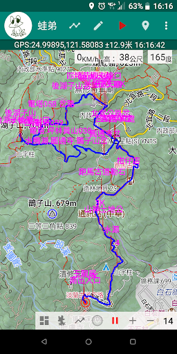
Pair them with map files and GPS positioning to make it clear to you.
Know where you are currently, whether you deviate from the reference trajectory, the height difference from the destination and the distance to help you reach your destination smoothly and return home safely.When engaging in outdoor activities, turn on the GPS positioning function (GPS positioning permission must be allowed), and Wadi can also record your trajectory.
After you return home safely, Wadi can help you edit this track record, and further assist you in generating a GPS file (gpx/kml/kmz) from the track record.
You can share your track with your relatives and friends.
Record files so that your relatives and friends can enjoy the same outdoor trip as you safely, smoothly and happily.
In addition, based on your itinerary records, Wadi will thoughtfully generate itinerary summaries, height difference maps, and map photos for you, allowing you to more completely share your colorful itinerary records.
If you are familiar with Google Earth Pro, Wadi can even create a Google Earth Pro Tour script file (kml/kmz) for you, allowing you to show your actual scene in a more vivid, lively and clear way.
The ups and downs of the trip and the beauty of the surroundings.Wadi can not only read the GPS files on your mobile phone, but also conveniently assist you in editing these files.
After importing the GPS files on your mobile phone, you can: split tracks, merge tracks, add new files /Modify/delete marks and delete waypoints to make the track file more in line with your itinerary needs.
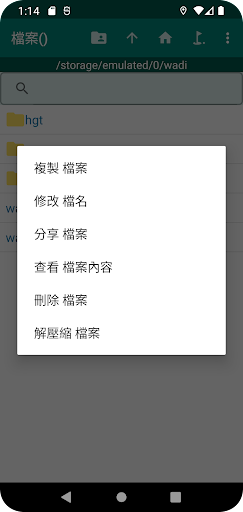
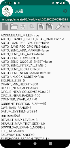
If you are familiar with the specifications of GPS files, you can even use Wadis built-in "Document" function to directly modify GPS files.When you need to change your phone, Wadi provides the function of backing up/restoring track record files.
Since you usually have rich track records, this process takes a long time, so please be patient.
When replacing a mobile phone, in addition to backing up/restoring the track record files, it is usually also necessary to back up/restorate Wadis setting parameters.
Please go to the "Settings" function to back up/restor all parameters.In order to allow you to engage in outdoor activities safely and avoid getting lost, Wadi can not only manually transmit the current coordinate position to ask for help; with your consent, Wadi can also automatically send calls to your relatives and friends at regular times and at fixed points.
Communication groups (Line, Telegram, Google Form) report coordinates.
In case you are unfortunately lost, fall, or injured, the rescue unit can narrow the search scope, quickly contact your location, and help you seek medical treatment or return home as soon as possible.
In fact, when recording a track and opening a reference track file, Wadi can automatically sound a sound to remind you when you deviate from the track or approach a mark on the track.
Such reminders can also be set to automatically send notifications.
to the communication group you have set up in advance.In addition, considering your needs for outdoor activities, Wadi also provides the following additional functions:1.
Check list file management: You can import the equipment required for the event into Wadi in csv file format, and check whether the equipment is complete one by one.
You can also export Wadis checklist to a csv file to share with your relatives and friends.
When changing your phone, don’t forget to go to the checklist function to perform backup/restore work.2.
Weather forecast query: After opening the GPS file, you can quickly query the surrounding weather forecast.
We provide two weather forecast query functions or links, Windy and OpenWeather.3.
Taiwan Meteorological Bureau rainfall observation record query: In the "CWA Rainfall Station" function, you can query the rainfall observation records of rainfall stations near the reference track within three days.
Note that this feature is only available in Taiwan.4.
Real-time image query: You can query real-time images of national highways/provincial highways/ports/scenic spots around the reference trajectory.
This feature is also only available in Taiwan.5.
Sunrise/sunset time query: You can query the future sunrise/sunset time around the reference trajectory to reduce the anxiety and problems caused by being in the dark.6.
Holding a placard: Is there no appropriate placard to use when taking pictures at the top?
Try Wadis "raise a sign" function.
It is not only convenient and easy to use, but also can achieve the state of "LNT" (LNT).7.
Supports multi-point distance measurement and can be saved as a GPS file to become a reference track file for your exploration activities.8.
Support WGS84/TWD97/TWD67 coordinate conversion.Welcome to join our Facebook community (https://www.facebook.com/groups/wadiapp) to get more information and the fastest version update notification.
Music Features
Enjoy high-quality music streaming and playback features.
Social Features
Connect and share with friends and the community.
Gaming Features
Enjoy immersive gaming experience with various game modes.
See the 蛙弟 wadi- 地圖/GPS檔案的檢視與維護工具 in Action
Get the App Today
Available for Android 8.0 and above